Figure 1 – Researchers from Montana State University and University of Montana found that Light Detection and Ranging (LiDAR) could provide exterminators a cost-efficient tool to locate invasive lake trout in Yellowstone Lake. Picture courtesy of the National Park Service.
New research from Montana State University and the University of Montana suggests that Light Detection and Ranging (LiDAR) could provide conservationists at Yellowstone National Park with a critical tool to improve biodiversity and ecological conservation. One key challenge of ecological conservation is how to address the issue of invasive species’ introduction into ecosystems. An invasive species is defined as a species that has been introduced by people into an area in which they did not originate. Often, introducing these species was well intended, and might have been done to eradicate a common pest in an area. Unfortunately, however, because these animals did not evolve in the ecosystem where they were brought, they have no natural predators and can easily takeover and overwhelm ecosystems and cause substantial environmental damage.
One such invasive species is the lake trout that overran Yellowstone Lake within the famous Yellowstone National Park. This species of fish was introduced more than thirty years ago in order to attract fishermen to the park. The lake trout quickly began to takeover their environment. These invasive fish preyed on the native trout species, which were the main food source of the area’s apex predators. As such, native species on both ends of the food chain were negatively affected by the introduction of the lake trout and the biodiversity of the surrounding area began to suffer significantly, with some local species declining by as much as 90% in five years.
As the problem got progressively worse, it was clear that it needed to be addressed, and the National Park Service began working to remove these invasive lake trout from Yellowstone Lake with large nets. Given the sheer number of lake trout, a research team from Montana State University and the University of Montana developed a method to optimize the efforts of these fishermen. These scientists found that they could utilize Light Detection and Ranging (LiDAR), a technology similar to RADAR, in order to locate the invasive lake trout and their breeding grounds to guide the efforts of the fishermen so they could exterminate them more efficiently. These researchers also managed to create a LiDAR system that would be cheap enough to be used regularly by conservationists to monitor the lake’s fish population. With the aid of engineers from Montana State University, they created a LiDAR system that would only cost $500 per day to use.
LiDAR: What it is and How it Can Be Used
LiDAR is a technology that can be used to create mappings of its surrounding environment. It does this by using a laser light source to fire thousands of light pulses per second at the surrounding environment and measuring how long it takes these pulses to return after they reflect off of nearby objects. Given that the speed of these light pulses is a constant, the light pulses that take longer to return are those that were reflected off of more distant objects, while those that take less time were reflected off of closer objects. Using this basic principle, the device integrates the data its receptor receives and can create a map of any environment that light can permeate, including underwater.
While LiDAR cannot accurately map extreme depths, it does work well in more shallow waters where fish like the invasive lake trout swim. While some of the light pulses are, of course, reflected off of the surface of the water, others pass through and can also map beneath the surface. Just as LiDAR’s laser’s light pulses can reflect off of nearby objects, it will also reflect off of fish swimming underwater and reveal their location.

This picture of the Bixby Bridge in Big Sur, California illustrates the type of mapping that can be created by a LiDAR detector. The image on the top right is an aerial view of the bridge, while the one immediately beneath it is a profile view. Picture courtesy of the National Ocean Service.
One of the greatest advantages of LiDAR is that, because light travels more quickly than anything else, it can gather a lot of data efficiently across large areas. As such, this technology can be taken aboard a fast-moving helicopter or airplane and could map hundreds of acres, such as Yellowstone Lake, and create images such as those shown in the figure above. This advantage combined with LiDAR’s ability to map underwater spaces suggested to the Montana scientists that the technology could be used to monitor the activity of Yellowstone’s invasive lake trout.
Tracking Yellowstone’s Lake Trout with LiDAR
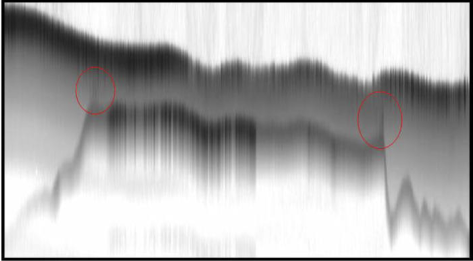
While LiDAR showed promise for aiding in ecological conservation, its implementation was not without challenges. Until recently, it had never been used to try and monitor the activity of fish living in lakes, in part because lakes have much cloudier water that adds noise to the light’s signals. As such, the data indicating the presence and position of the lake trout is not nearly as crisp or clear as that shown in the image of the previous section. Instead, the LiDAR data is much fuzzier, as shown in the picture below.

A zoomed-in image of LiDAR data indicating the presence of a lake trout, the edges of which are indicated by the area circled in red. Picture from Shaw et al., “Airborne LIDAR Mapping of Invasive Lake Trout in Yellowstone Lake.” Accessed from http://www.montana.edu/jshaw/documents/ILRC24_YstoneLidar.pdf
Unfortunately, this LiDAR data does not definitively identify the species of fish detected by LiDAR on its own. If, however, this data is considered together with the depth at which the signal was detected and the region of the lake in which it was found, a reasonable guess can be made at identifying the fish species. In the case of the lake trout, this strategy promises to be particularly effective, because they tend to swim at a characteristic depth that many other fish do not. By regularly monitoring the lake trout population, ecologists can have a better idea of where exactly their habitats and breeding grounds are, and will therefore better enable them to control the existing population.
To read more about the use of LiDAR to control the lake trout population in Yellowstone Lake within Yellowstone National Park, click here.
