Both LiDAR and RADAR are well-established methods of detection and remote sensing. Some systems benefit from using radar while others are better served using LiDAR. In some cases, the two techniques may work in tandem, like in some autonomous vehicle prototypes. So, how do each of these systems work, what exactly are they used for, and how are they different?
RADAR
RADAR is a method of electromagnetic detection and can use either radio waves or microwaves. The term RADAR stands for Radio Detecting and Ranging. While it is an acronym, it is commonly written simply as ‘radar’. Using radar, the radio waves are sent out in pulses. When the waves encounter objects obstructing the path of the wave propagation, some of the signal may be partially reflected or scattered. From the reflected energy making up the return signal, it is possible to determine how far away an obstruction is.
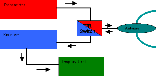
A traditional radar system can be broken down into four major elements. The first is the transmitter. The transmitter creates the signal to be sent out. The signal goes from the transmitter to a transmit/receive switch. The transmit/receive switch then dictates when the system is sending out a signal and when it receives the signal. This signal is then sent to the third component: an antenna. The antenna is used to both send out the pulses and receive the reflected ones. When set to the receiving mode, the pulses detected by the antenna are sent to a receiver where they are detected and amplified. These signals are then converted to a useful format and displayed to the user. Object locations and their presence are determined based on the speed the pulses being sent out are travelling and the time it takes for the reflected signals to be received.

Schematic Diagram of a RADAR. Courtesy of Australian Government Bureau of Metrology
An interesting fact: the first form of radar for detecting targets was proposed in 1904 by Christian Hülsmeyer. His intent was to create a device that would detect obstacles and aid in maritime navigation. He called this device a Telemobiloskop. While he built his invention, it was of little interest to his fatherland’s (Germany’s) navy at that time. However, this was not the case for long. By the 1930s with World War I underway, numerous nations had come up with radio-based systems to detect aircrafts. By the time World War II began, multiple countries had functional radar systems.
LiDAR
LiDAR is an acronym that stands for Light Detection and Ranging. It was developed after both radar and sonar. LiDAR is a remote sensing system—an active remote sensing system to be precise. Active remote sensing means that the system generates energy (or light) itself. The light being emitted is sourced by a quickly pulsing laser. The pulses occur at such a rapid rate that in some cases there are as many as 150,000 pulses emitted in a single second (rep rate of 150kHz)!
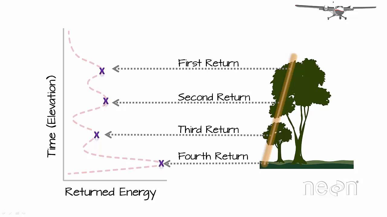
Similar to radar, some of the transmitted light gets reflected off objects and received by the LiDAR sensor. Similarly, the LiDAR system uses the time it takes for the reflected light to return to determine the distance of an object. The peaks in the intensity distribution of the returned light help identify where an object may be located. This location or distance can in turn be converted to other quantities, like elevation or topography.

The distribution of reflected energy over time determines the spatial profile of the scanned object. Courtesy of Neon Science.
RADAR vs LiDAR
Clearly both RADAR and LiDAR are advanced technologies that can be used for ranging or tracking objects, but when is one preferred over the other? As we just saw, radar uses signals at radio frequencies. While the concept of operation is similar in both cases, waves in radiofrequencies are known to travel large distances unperturbed by common obstructions such as atmosphere (fog, cloud). However, it comes with a disadvantage of a lower resolution, which is basically determined by the bandwidth of the transmitted pulse.
Conversely, LiDARs need unobstructed travel space but offer markedly enhanced accuracy given the much smaller wavelength of the source. They offer much better accuracy when it comes to locating objects and relaying their distances. Unfortunately, LiDARs require more sophisticated technology that makes these systems much more expensive than radars. The sensors and equipment for radar come at a cheaper cost than that used for LiDAR.
The high resolution of LiDARs makes them a great tool for various modern applications including land surveillance, unmanned reconnaissance drones, power line inspection, mining, forestry, farming and most recently in autonomous driving.
LiDARs vs Traditional Cameras
LiDAR is an advanced technology that requires highly calibrated equipment. It can be affected by wavelength stability or detector sensitivity/calibration. It also requires much higher computing power than traditional cameras. If LiDARs use light to detect objects, why not then use traditional cameras to obtain the same information? The main advantage that LiDARs offer that makes them superior to cameras in certain applications is their ability for range detection and topography rendering. This added, depth/distance information is proven to be crucial in many applications listed above.
Clearly, the application of the system must be carefully considered before choosing the most appropriate remote sensing method. Whichever method is selected, though, one can be confident in that both are tried and true options for detection.
Today’s post is sponsored by DataRay Inc. – a leader in laser beam profilers.
