Precision agriculture is the practice of micromanaging crops to maximize yield, with the help of sensors, mapping techniques and laboratory studies like spectroscopy. This type of “smart” farming is especially useful for optimally using scarce resources like land, water and fertilizer. Technologies like GPS and radar paved the way for this practice, allowing farmers to easily measure their fields. From there, they could accurately distribute water and fertilizer to the areas in need. As large-scale farming became prominent, agriculture has been more reliant on data over the years. As agricultural sensing methods become accessible, it can reach smaller farms and benefit their processes.
Sensor based technology is more accessible than ever before and is playing an increasingly important role in collecting information for farmers. Optical sensors retrieve detailed info on soil, plant health, heat/climate, water contents, contaminants and many more vital pieces of the agricultural process. Advancements in data storage and connectivity allow all-encompassing software packages to link information about each variable that could influence the farmer’s decision making. Most importantly, all this data and analytic intelligence is now available for remote access. For instance, as software and sensors become integrated with functions on the farm, applications on a computer or smartphone can control watering and fertilization.
These changes all begin with the foundation of accurate and informative sensing technology. Interest in environmental and economic sustainability has driven farmers to find new ways to optimize. In this blog post, we will explore a few different ways that spectroscopy helps sustain the crop, and prevent crop illness.
Spectroscopy and Crop Health
Wheat, along with other key crops, are heavily reliant on nitrogen fertilizer to produce consistent yields. However, a uniform distribution of fertilizer has proven to be ineffective. Site specific measurements must be taken, since nitrogen levels in different terrains will vary. To address this researchers use the Vegetation Index to make predictions about wheat crops, such as water and fertilizer requirements. The Vegetation Index takes an inverse correlation between red and near-infrared light to assign a quantitative measurement to a plant’s vegetative stage. Essentially, it judges a plant’s health by studying the vibrancy of its color. This helps to segment a crop based on its needs or stresses.
Vegetation Index studies are gaining more traction with developments in spectroscopy, especially RGB (red-green-blue) spectroscopy. The name is self-explanatory: it is the study of red, green and blue emissions from different materials. This practice is especially helpful to determine a crops position in the Vegetation Index. Now that small sensors and cameras are capable of efficient spectroscopy, researchers need not take soil or plant samples, and run costly lab tests to find specific water, nitrogen or protein contents. Vehicles like tractors or drones can mount these sensors and collect crop metrics using only images.

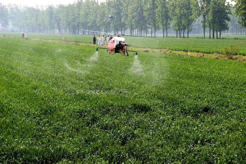
A UAV drone hovers over a wheat crop, spraying fertilizer. During these flights, the drone takes aerial images of the crop. Researchers then detect areas of the crop that are under stress. Photo courtesy of Pixabay.
This makes precision agriculture much quicker and easier, since there is no intermediary laboratory test. It encourages the use of spectroscopy in agricultural decision making. By checking the Vegetation Index, people can find areas that are lacking water, depleted of nitrogen, or genetically weaker. From there, farmers can act to manage these stresses by optimally redistributing water and fertilizer. Micromanaging nitrogen inputs and crop outputs have been one of the most notable accomplishments in precision agriculture. Heavy research goes into extending the range of spectroscopic sensors and will provide even better solutions for vegetative mapping of large fields in the near future.
Preventing the Spread of Disease
As mentioned previously, these mobile spectroscopy methods can map crop health in many ways. Disease control is another area which is being explored with UAV-mounted sensing technology. Crop illnesses spread quickly if not managed and are often hard to trace if it is a soil condition like root rot. Treatment usually entails using expensive fungicides or relocating portions of the crop altogether. It is a massive issue for farmers, especially for people without immediate access to test kits or labs to find the cause in time to stop it. Typically, these people won’t have specialized fungicides or large equipment to uproot infected plants either.
Fungal root rot affects crops like cotton, alfalfa and many types of nuts. UAVs give farmers an aerial view and take images to find diseased portions of crop. Spectroscopic imaging provides even more information and is in the process of achieving longer range and wider resolution. The advantage to these methods is that UAVs are relatively cheap and are becoming more accessible in rural areas. In lieu of costly spectroscopic UAV setups, the images can simply be sent to a professional who can identify the disease. In any case, UAVs can easily produce an aerial map of crops which can be applied to a number of studies. It is important to address pressing needs like disease before the technology is used for more non-urgent purposes.
Scaling Down to the Smartphone

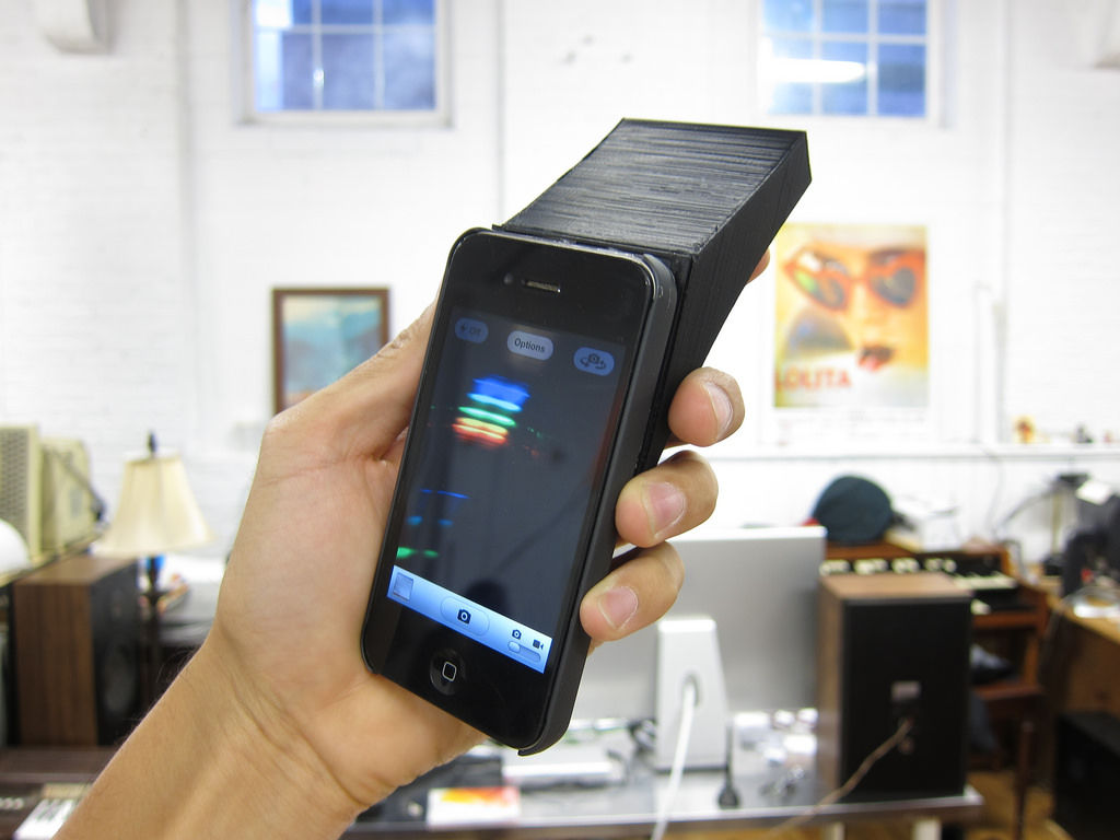
Smartphone spectrometers, like the one pictured above open up a world of possibilities for precision agriculture. With simple red, green and blue spectroscopy, a smartphone can identify a variety of problems in a crop. Picture courtesy of Jeff Warren from Flickr.
Smartphones are gaining traction among small scale farmers to perform the same analyses that only large factory farms have previously had access to. Developers have created a smartphone attachment and application for simple spectroscopy. It uses the smartphone camera combined with a small spectrometer to analyze the fluorescence of chlorophyll in plants. Chlorophyll levels indicate a plant’s stage in photosynthesis, and thus its ripeness. The advantages of this are obvious: it is quicker, cheaper and doesn’t require disturbing the crop.
Smartphone cameras go as far as to determine water needs or a plant’s stage in growth. The leaf area index is the ratio of vegetation area to ground area in an area like a crop or forest. It is widely used in ecology to monitor the growth patterns of forests, and in agriculture to study plant health. Researchers use a smartphone equipped with a fish eye lens (costs around $20) to capture the leaf area index without needing to take samples. From there, the images can be fed into traditional software that predicts crop outcomes based on the index. Ideally, this process would all take place in a smartphone application.
The trend in photonics applications is to scale down size and to make it portable, while, hopefully, staying cheap and accessible. Smartphones and UAVs are two of the best solutions for small-scale studies or wide-ranging images respectively. This is especially true in agriculture, as production occurs over large spaces with ever-changing terrain and weather conditions. This industry relies on getting as much information from the crop as possible. It’s now easier than ever to get in-depth crop information without needing to employ time consuming laboratory research.

Interesting article which shows that wearable spectroscopy will definitely open a whole range of new applications, in particular for precision agriculture.
ALPhANOV developed a few years ago a commercial smartphone-based light spectrometer: http://www.alphanov.com/223-news-gospectro—the-power-of-spectroscopy-at-your-fingertips.html
This device is also featured on the Findlight website: https://www.findlight.net/light-detection-and-measurement/spectrometers-spectrographs/spectrographs-and-monochromators/gospectro-alphanov-smartphone-based-light-spectrometer
Which MIR sensor is best suitable for analysing the soil Nitrogen,Phosphorus,Potassium and total carbon